Qualitative soil protection requires soil information, spatial planning requires practical tools
Soil information is a prerequisite if soil quality is to be considered in spatial-planning decisions. NRP 68 shows how other countries deal with soil information and how soil quality could be taken into account using soil indicators.
How do other European countries generate soil maps and make this information available? The focus study Soil information systems shows clearly that Switzerland lags behind other countries. Political actors are already aware of this. In the next few years, a Swiss soil information platform will be established in the context of a soil competence centre.
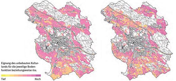
But even if the data were available, spatial planners don't know - even if they were willing to - how to consider soil quality in planning decisions. To eliminate this shortcoming, researchers of the Multicriterial compensation project developed a tool to assist planners in their decision-making based on three principles. The researchers of the Soil indicators project adapted an existing soil quality index for Stuttgart with the aim of making it useful for guiding spatial development in Switzerland. In addition, they developed a new soil quality index which considers either the various ecosystem services provided by the soil or the preferences of the different interest groups.